
A groundwater assessment before buying land tells you how deep the water sits beneath a site, how far that level moves through the year, and how the water will affect your excavation, foundations and approvals. You already check zoning, title, soil strength and contamination before you buy. Groundwater belongs on the same list. So does the ground the water moves through. Rock levels, clay layers and seepage paths decide where water collects and where excavation slows down.
Groundwater is the water held in the pores and cracks of soil and rock below the ground surface. The top of the saturated ground is called the water table. On one site the water table may sit a metre below grade. On another it may lie well below any planned basement.
That depth shapes the project. A shallow water table can require construction dewatering, waterproofed basements and heavier foundations. Poor water quality can trigger environmental approvals or cleanup. A seasonal rise can flood an excavation months into the programme.
Each of these conditions changes cost, schedule or design. Found before purchase, they inform the price, the contract terms and the decision to proceed. Found after purchase, they become your problem.
What Is a Groundwater Assessment Before Land Acquisition?
A groundwater assessment is a structured study of the water beneath a site and how that water will interact with a proposed development. Hydrogeologists carry out the work. Hydrogeology is the study of how groundwater occurs, moves and changes in quality. For background, see our guide to how groundwater moves through soil and rock.
The scope varies by site. A greenfield plot for single-storey warehouses may need only a desktop review of existing records. A city-centre plot for a tower with three basement levels may need boreholes, months of water level monitoring and pumping tests. The assessment scales to the risk the project carries.
What Does a Groundwater Assessment Examine?
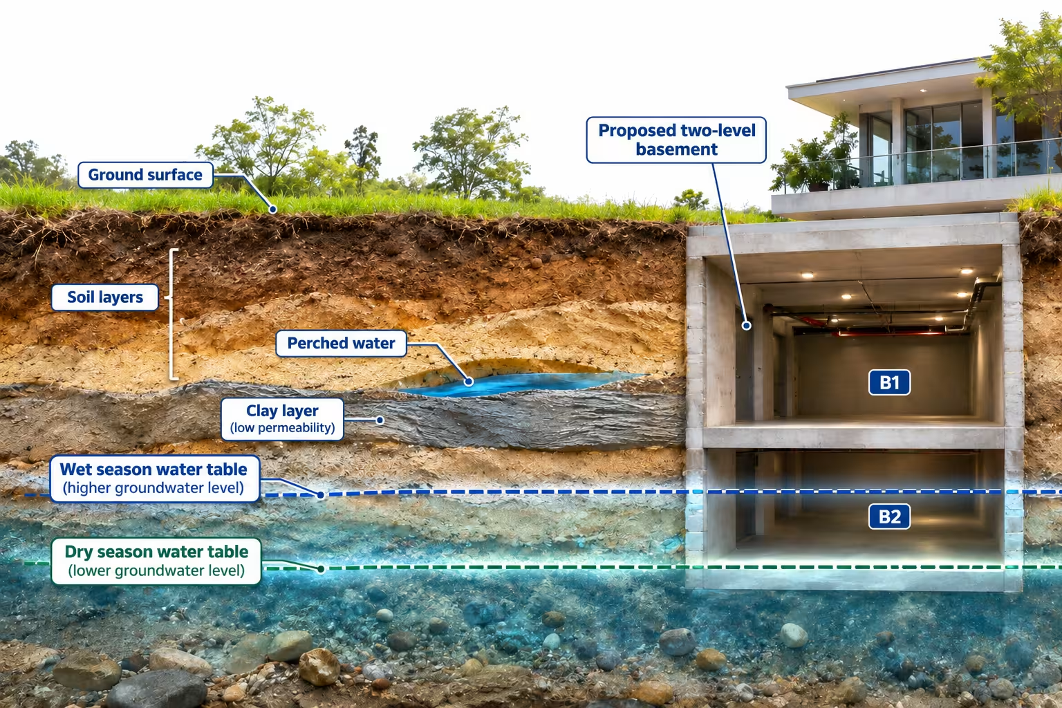
Groundwater depth. The assessment measures how far below the surface the water table sits. Readings at several points show how the level varies across the site.
Seasonal fluctuations. Water levels rise after wet seasons and fall in dry ones. The USGS notes that the range and timing of these changes can differ between aquifers in the same area. A single reading shows one moment, not the design condition.
Aquifer characteristics. An aquifer is a body of soil or rock that stores and transmits water. Gravel, sand, sandstone and fractured limestone form common aquifers. Clay transmits little water. Some sites hold perched water, a local saturated layer resting on clay above the main water table.
Groundwater movement. Groundwater flows from areas of higher water pressure to lower pressure. Direction and speed matter. A basement can block flow and raise levels on its upstream side. Pumping can draw contamination toward the site.
Hydraulic conductivity. Hydraulic conductivity measures how easily water moves through soil or rock. Values in clean gravel can exceed those in clay by a million times or more. This one property drives how much water an excavation will take on and how hard dewatering will be.
Groundwater quality. Where land history or setting suggests a risk, the assessment tests for contaminants, salinity and chemicals that attack concrete or steel.
Interaction with the design. The assessment compares water levels with excavation depths, foundation types and below-ground structures.
Environmental constraints. Nearby wells, springs, wetlands and protected aquifers can limit how much water a project may pump or discharge.
Groundwater Assessment vs. Geotechnical Investigation
A geotechnical investigation tests the strength, stiffness and settlement behaviour of the ground so engineers can design foundations and earthworks. Most geotechnical investigations record groundwater where boreholes strike water. Many install standpipes for later readings.
A groundwater assessment focuses on the water itself: where the water comes from, how the level changes, how fast the water moves and what the water contains. The two studies overlap, and they work best when planned together.
| Aspect | Geotechnical investigation | Groundwater assessment |
|---|---|---|
| Main question | Can the ground carry the structure? | How will groundwater affect construction, design and approvals? |
| Typical water data | Water strikes and short-term standpipe readings | Monitored levels over time, flow direction, hydraulic tests, water quality |
| Time span | Days to weeks of fieldwork | Days for a desktop review, months where seasonal monitoring is needed |
| Key outputs | Bearing capacity, settlement, soil parameters | Design groundwater levels, inflow and dewatering estimates, permit needs, quality risks |
| Main users | Structural and geotechnical engineers | Developers, designers, contractors and regulators |
Shared boreholes cut cost and give one consistent ground model. Both studies feed a conceptual site model, a written and drawn description of the ground, the water and how they behave together.
Why Groundwater Conditions Matter Before Buying Development Land
Groundwater rarely stops a project outright. More often, groundwater changes the design, the budget and the programme. The ten issues below explain how, and what to check before you commit to a purchase.
1. High Groundwater Tables Can Affect Excavation and Basement Construction
When an excavation goes below the water table, water flows into the hole. In sand and gravel, inflow can be fast. Water rising through the base of a dig can loosen sand until the floor loses strength. Engineers call this base instability, or piping. Side slopes can slump.
The response depends on the ground. Options include lowering the water by pumping, building watertight walls such as secant piles or diaphragm walls to cut off flow, or reducing the basement depth.
Before purchase: compare the deepest planned excavation with the highest likely water level. If the basement sits below that level, the cost of groundwater control belongs in your land appraisal.
2. Groundwater Conditions Can Influence Foundation Design
Groundwater reduces the effective stress in soil. Effective stress is the share of load carried by the soil grains rather than the water between them. Lower effective stress means lower bearing capacity. Soils below the water table can also settle differently from the same soils above.
Water chemistry affects foundations too. Sulfates in groundwater can attack concrete. Chlorides can corrode steel reinforcement. Sites with saline groundwater, common near coasts and in arid regions, need durable concrete mixes and protective measures.
Before purchase: confirm the planned foundation type still works with the measured water level and chemistry. A switch from pad footings to piles changes cost early in the appraisal.
3. Construction Dewatering Can Increase Project Complexity and Costs
Construction dewatering is the temporary lowering of groundwater so work can proceed in dry conditions. Common methods include sump pumping, wellpoints and deep wells. The industry guide CIRIA C750, Groundwater Control: Design and Practice explains how method choice depends on soil permeability and the depth of lowering.
Dewatering involves more than pumps. A project may need an abstraction licence, a discharge permit, water treatment before discharge and monitoring of neighbouring buildings. Lowering groundwater can cause soft clays, silts and peat to compress, which can settle nearby structures. On a regional scale, the same process explains why the USGS names aquifer-system compaction as the leading cause of land subsidence in the United States.
Not every site needs dewatering. Shallow foundations above the water table, or watertight cut-off walls, can avoid most pumping. Where pumping is needed, plan construction dewatering from measured site data.
Before purchase: estimate whether dewatering is needed, for how long and at what rate. Ask which permits apply and how long they take to obtain.
4. Groundwater Pressure Can Affect Underground Structures
Water below the water table pushes on every buried surface. Engineers call this hydrostatic pressure. Pressure rises with depth, by about 10 kilopascals for each metre below the water table.
Two effects follow. Basement walls and floor slabs must resist water pressure from the sides and below. Light structures can also float. This is called buoyancy, or uplift. Empty underground tanks, shallow car parks and basements under construction, before the building's weight sits on them, face the highest risk. Designers counter uplift with heavier slabs, tension piles or ground anchors.
Basements also need waterproofing suited to their use. A plant room tolerates more damp than a data hall or archive. In the UK, BS 8102:2022 sets grades of protection against water ingress for below-ground structures.
Where an existing basement on or next to the site already shows damp or leaks, a basement seepage investigation traces the water to its source. That tells you whether the fix is local drainage, groundwater control or a redesign, before you price the site.
Before purchase: check uplift and waterproofing costs against the highest credible groundwater level, not the level recorded on the day of drilling.
5. Seasonal Groundwater Fluctuations Can Change Site Conditions
Groundwater levels change through the year. The USGS explains that the water table often rises in late winter and spring as rain and snowmelt soak in, then falls in hot, dry summers. In monsoon climates, levels usually peak after the monsoon. Near coasts and tidal rivers, levels can rise and fall each day.
A site investigated in the dry season can look drier than it is. A borehole drilled before the monsoon in southern India, or in late summer in Europe, may record a level well below the wet-season peak.
Long-term trends matter too. Where heavy pumping stops, for example when industry closes, groundwater can recover toward its natural level. This is called groundwater rebound. Basements built during low levels may later sit below the water table.
Before purchase: ask when existing readings were taken. Where possible, collect readings across at least one wet season, or compare site data with long-term records from nearby monitoring wells.
6. Groundwater Contamination Can Create Environmental and Financial Risks
Groundwater can carry contamination from landfills, septic systems, leaking fuel tanks, industrial sites and over-applied fertilisers. Because groundwater moves, a clean site can sit down-gradient of a polluted one.
Contamination creates three exposures. The first is cleanup liability, which in some jurisdictions can pass to a new owner. The second is construction cost, since contaminated water pumped during dewatering may need treatment before discharge. The third is building safety. The US EPA explains that vapor intrusion occurs when vapor-forming chemicals migrate from a subsurface source into an overlying building.
Before purchase: review historical land use on and around the site. In the United States, a Phase I Environmental Site Assessment under ASTM E1527-21 is the recognised way to meet the EPA All Appropriate Inquiries rule. A Phase I reviews records and inspects the site. Groundwater sampling normally follows in a Phase II where concerns are found.
7. Groundwater Conditions Can Influence Environmental Approvals
Many regulators control who may pump groundwater, how much and where the water goes. Approvals for dewatering, discharge or well drilling can add weeks or months to a programme. Protected aquifers, drinking water wells, springs and wetlands nearby can tighten the conditions.
Some planning authorities ask for groundwater evidence before they grant consent. The London Borough of Camden, for example, states that all basement proposals should go through the screening stage of a Basement Impact Assessment, with groundwater flow among the impacts assessed.
Before purchase: list the approvals the groundwater conditions will trigger, the authority for each and the usual timescales. Build the longest approval path into your programme.
8. Unexpected Groundwater Can Disrupt Construction Schedules
Unexpected groundwater can stop work below ground. A flooded excavation halts piling and concreting. Pumps must be mobilised. You may need permits mid-project. Uncontrolled inflow can wash fine soil out of the ground and undermine nearby slabs, roads or services.
Delay costs more than the direct works. Crane hire, site overheads, finance charges and late-completion penalties keep running. Early data turns an unknown into a planned and priced activity.
Before purchase: ask how much groundwater data exists for the actual building footprint, not only for the general area. A gap in data is a risk in its own right.
9. Groundwater Availability May Affect Long-Term Development Planning
For some projects, groundwater is a resource. Industrial plants, data centres, large townships and landscaped campuses may plan to draw water from on-site wells, or to put rainwater back into the ground through groundwater recharge.
Availability depends on aquifer yield, water quality and local rules. In India, for example, the Central Ground Water Authority restricts new groundwater extraction for many projects in over-exploited and critical areas, with exceptions such as drinking and domestic use. A plan that relies on bore wells may not be permitted, or the aquifer may not sustain the demand.
Before purchase: if the project needs groundwater for supply, cooling or irrigation, confirm yield, quality and permit status. If the plan includes recharge, confirm the ground can accept water without raising levels under foundations.
10. Shallow Rock and Subsurface Strata Shape Both Excavation and Groundwater Flow
Rock that sits higher than expected changes the excavation plan. Breaking or blasting rock costs more and takes longer than digging soil. On a deep basement, an unplanned rock bed can push the programme by weeks and raise finance costs while the site waits.
Rock also controls groundwater. Water often perches on top of rock or clay and seeps sideways into excavations. Fractures in weathered rock can carry water fast in one direction and almost none in another. Two boreholes a few metres apart can show different rock levels and different water conditions.
A few boreholes describe the ground at a few points. Mapping the strata across the whole footprint shows where rock rises, where water collects and where seepage paths run between the test points.
Before purchase: ask whether rock levels and water-bearing zones are mapped across the full footprint, or only at the borehole positions. Price rock excavation and seepage control into the appraisal where the data shows either one.
How Groundwater Conditions Affect Different Types of Property Development
The same water table creates different risks for different buildings. Use, depth below ground, tolerance for damp and water demand decide which questions matter most.
Residential Towers and Apartment Developments
Towers often carry two to four basement levels for parking and services. Deep basements in dense cities raise two questions. Can the excavation be kept dry without settling neighbouring buildings? Will the finished basement resist uplift and water pressure for the life of the building?
Residential sales also depend on a fixed handover date. A groundwater delay in the basement pushes every later trade. For these projects, design groundwater levels and the cut-off wall strategy deserve attention at the land appraisal stage.
Commercial Office Buildings
Office basements hold parking, plant rooms and sometimes retail links to transit stations. Occupied lower floors need a high grade of waterproofing, and tenants expect dry space.
City-centre sites add constraints. Pumped groundwater often discharges to public sewers or drains, which needs consent from the asset owner. Metro tunnels, utility lines and older buildings nearby may limit how far groundwater can be lowered.
Industrial Facilities and Manufacturing Plants
Industrial sites raise questions of supply and liability. Many plants plan to draw process water from on-site wells, so aquifer yield and quality matter. Machine foundations, pits and sumps below grade must also stay dry.
Industrial use can itself pollute groundwater over time. A baseline survey of groundwater quality before operations begin records what was already there. That record helps separate inherited contamination from any later impact.
Warehouses and Logistics Parks
Warehouses usually sit on shallow foundations with few basements, so dewatering demand is often low. Groundwater still matters. Large floor slabs are sensitive to uneven settlement. Dock levellers, loading pits, drainage tanks and attenuation storage all sit below grade.
Groundwater depth also limits drainage design. Soakaways and infiltration basins need unsaturated ground beneath them. A high water table can rule out infiltration and require larger on-site storage instead.
Mixed-Use Developments
Mixed-use schemes often build in phases over several years. Conditions measured for phase one may differ by phase three. Dewatering for a later phase can also affect a completed phase next door.
Different uses tolerate different conditions. A shared basement may combine residential storage, retail service yards and car parking, each with its own waterproofing need. A phase-by-phase groundwater plan avoids redesign later.
Data Centers and Critical Infrastructure
Data centres tolerate almost no water ingress in electrical and equipment rooms. Below-ground cable routes, fuel tanks for backup generators and cooling plant all need protection from groundwater and groundwater flooding.
Cooling can create water demand. Some designs consider groundwater for supply or heat exchange, which brings yield, quality and permit questions. Buried fuel tanks add buoyancy and leak risks. For critical facilities, the design groundwater level should reflect wet-season peaks and long-term trends, not average conditions.
When Should Developers Conduct a Groundwater Assessment?
Start before you sign. Groundwater work then continues in stages, each one more detailed than the last, as the project moves from a site option to a construction contract.
- Preliminary land screening. At the shortlist stage, a desktop review checks geology, mapped water levels, flood and groundwater susceptibility, nearby wells and past land use. The goal is to spot sites with obvious groundwater constraints before money goes into detailed studies.
- Pre-acquisition technical due diligence. Once a site is under offer, the review becomes site-specific. Existing borehole logs, seller reports and a site walk-over test the screening findings. Where the planned basement approaches the likely water table, a short intrusive investigation can follow during the exclusivity period.
- Development feasibility assessment. With a concept design in hand, the assessment compares water levels against real excavation depths. The output is an early estimate of groundwater control, waterproofing, foundation and permit needs, priced into the appraisal.
- Detailed design and pre-construction investigation. Before construction, monitoring, hydraulic testing and, where needed, groundwater modelling set the design groundwater levels and the dewatering design. Permit applications draw on this data.
Early screening can identify issues before purchase, when you still have the most choices. Screening does not replace later investigation. Regional data cannot show perched water, local contamination or the exact level beneath your footprint. Each stage should confirm or correct the one before.
What Does a Groundwater Assessment Include?
Not every site needs every component below. A hydrogeologist selects the components that match the site's risk and the decision you need to make.
Desktop Hydrogeological Review
A desktop review gathers existing information: geological and hydrogeological maps, government well and borehole records, previous site reports, historical maps and aerial images, and groundwater flooding data. In Great Britain, the BGS Groundwater Flooding Susceptibility dataset maps areas where groundwater may reach the surface or flood basements. In the United States, the USGS National Water Dashboard shows past and present depth-to-water readings.
Limitation: regional data has coarse resolution. The BGS states that its susceptibility data cannot be used on its own to indicate risk of groundwater flooding.
Site Reconnaissance and Existing Borehole Data
A site walk-over looks for springs, wet ground, water-loving vegetation, existing wells and signs of past pumping. Neighbouring basements and their drainage offer clues. Geotechnical reports from the seller or adjacent sites often include water strikes and standpipe readings.
Limitation: old borehole logs may be undated or incomplete. A water strike during drilling can differ from the level the water settles at hours or days later.
Geophysical and Subsurface Imaging Surveys
Geophysical surveys image the ground between boreholes without drilling more holes. Each method measures a different physical property. Seismic surveys track how sound waves travel through soil and rock, which helps locate the rock surface and layer boundaries. Transient electromagnetic (TEM) surveys and electrical resistivity tomography (ERT) map how easily the ground conducts electricity, which changes with clay content, saturation and salinity. Ground-penetrating radar (GPR) images shallow layers and buried features.
Combined with borehole logs and geospatial data, these surveys build a picture of rock levels, clay layers and likely water-bearing zones across the whole site. That picture shows where to place boreholes and monitoring wells so each one answers a real question.
Limitation: geophysics infers ground conditions from physical signals. Interpretation depends on the site, and results need boreholes, water level readings and hydraulic tests to confirm water levels, flow and aquifer properties.
Groundwater Level Monitoring
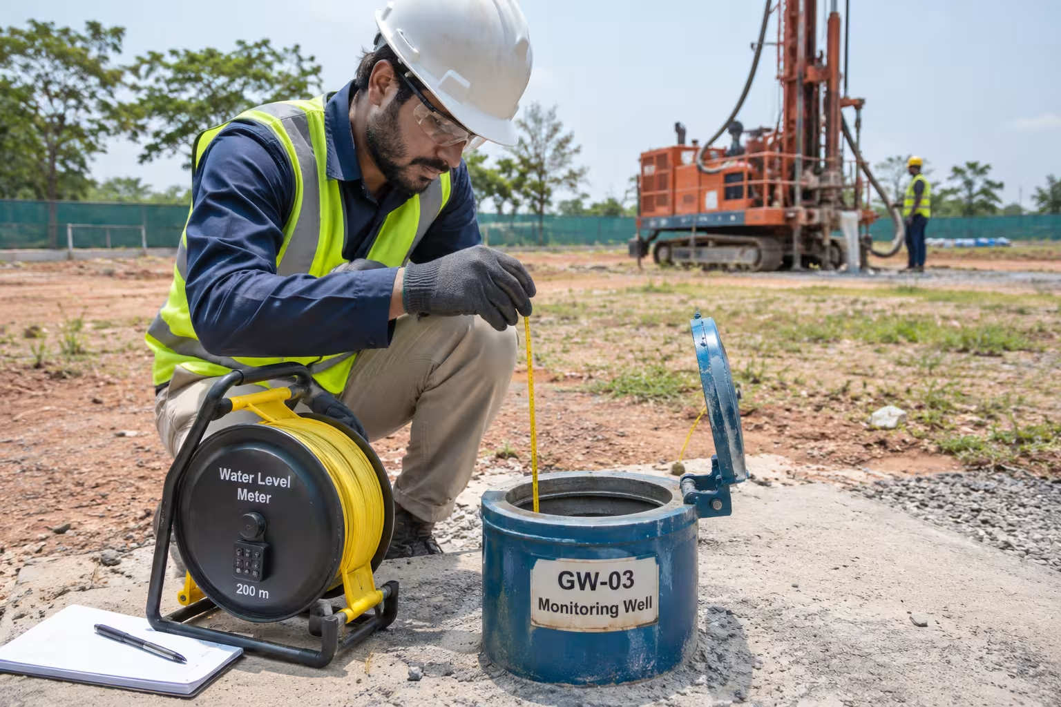
Monitoring wells, also called standpipes or piezometers, are narrow pipes installed in boreholes to measure water level or pressure at a chosen depth. Readings come from manual dips or automatic data loggers. Several wells across the site show flow direction and spatial variation.
Limitation: short monitoring captures only part of the seasonal cycle. Results from a dry month need adjustment before they become design levels.
Hydraulic Testing and Groundwater Flow Evaluation
Hydraulic tests measure how easily water moves through the ground. Slug tests and falling-head tests in single boreholes give quick, local values. A pumping test pumps a well at a controlled rate while nearby wells record the drawdown, the fall in water level caused by pumping. Results feed estimates of excavation inflow and dewatering design. Complex sites may need a numerical groundwater model.
Limitation: each test represents the ground near the tested zone. Variable ground can make results from one location unrepresentative of another.
Groundwater Quality Investigation
Sampling tests groundwater for contaminants linked to past land use, such as fuels, solvents and metals. Samples also check salinity, sulfate, chloride and pH, which affect concrete and steel durability and discharge options. Accredited laboratories carry out the analysis. Ongoing groundwater quality monitoring can track changes over time.
Limitation: a sample represents one place at one time. Contamination plumes move, and concentrations can change with season and pumping.
Groundwater Risk Assessment and Technical Reporting
The report brings the findings into one conceptual site model. Useful reports state design groundwater levels, expected inflows, likely dewatering methods, permit needs, quality risks and a ranked list of residual uncertainties. Good reports also separate what was measured, what was inferred and what was modelled.
Limitation: every assessment carries uncertainty. A clear report states the uncertainty and the further work that would reduce it.
How The Ground Water Company Assesses Land Before Acquisition
We study the subsurface as one system. Rock, soil, water and the land around the site all decide how a development will behave below ground. Our pre-acquisition work follows four principles.
We Read the Site in Its Regional Context
Groundwater does not stop at the property boundary. Recharge, flow direction, flood pathways and contamination often start off site. We review geology, drainage, topography, rainfall and nearby borewell data across the surrounding area, then narrow the study to the plot. A study limited to the boundary can miss the source of the water that reaches the basement.
We Map the Subsurface Layer by Layer
We combine geospatial mapping, subsurface imaging such as seismic and TEM surveys, and site data on a grid across the land. The result is a layer-by-layer view of rock levels, clay layers, water-bearing zones and seepage paths. Mathematical and 3D modelling then tests how the water will behave once you excavate, pump or recharge.
We Translate Findings into Acquisition Decisions
A developer needs answers, not raw survey data. Our outputs map the risks you will price:
- Rock maps showing where rock rises toward planned excavation levels
- Seepage maps showing where water is likely to enter basements and cuttings
- Flood-prone zones where water may collect during heavy rain
- Potential empty zones where the ground holds little water and borewells may underperform
- Recharge zones where rainwater can return to the aquifer without raising levels under foundations
Each map separates what we measured, what we inferred and what we modelled, so your engineers and legal advisers know how much weight each finding carries.
Project Examples
Residential developer, land acquisition. A developer that buys land parcels every year needed to screen candidate sites before purchase. Our subsurface study gave the team rock maps, seepage maps and maps of potential empty zones for each candidate parcel. The developer used these insights to avoid parcels whose hidden ground conditions would raise development cost.
Residential project, Bengaluru, 2023-24. Earlier projects had struggled to map rock strata, seepage and groundwater sustainability with confidence. We mapped the rock strata in detail. During excavation, the conditions found on site matched our report. We also identified aquifers for water supply and flood-prone zones, with mitigation recommended before construction began.
Commercial complex, Chennai, 2023-24. Seepage in the cellars had become a recurring problem for occupiers. The objective was to find the root cause and keep the water table below the raft. Our data identified 10 seepage zones. After work in the first 2 zones, the client saw reduced seepage and wall dampness in the cellars within two weeks of execution.
Similar work covers residential, commercial and campus developments across Bengaluru, Chennai and Mumbai.
How Much Does a Groundwater Assessment Cost Before Buying Land?
Cost depends on scope, and scope depends on the site and the decision at stake. A desktop screening of a simple site costs far less than a multi-season monitoring programme on a deep urban basement. The factors below drive the difference.
| Cost factor | Why it changes the cost |
|---|---|
| Site area | Larger sites need more monitoring points to describe variation |
| Geological complexity | Layered or fractured ground needs more boreholes and tests |
| Existing information | Good records from the seller or neighbours reduce new fieldwork |
| Investigation depth | Deeper boreholes cost more to drill and install |
| Monitoring requirements | Months of readings across seasons add site visits or data loggers |
| Laboratory analysis | Contamination suites cost more than basic chemistry |
| Technical modelling | Numerical groundwater models add specialist time |
| Local regulations | Some permits require specific studies, formats or accredited consultants |
| Reporting scope | A screening memo takes less time than a full design report |
Weigh the fee against the exposure an unresolved groundwater condition creates. Compare the fee with the cost of one month's delay on your programme, a change from shallow foundations to piles, a dewatering system running for the full basement build, or a contamination cleanup order. Those figures come from your own appraisal, and they set the value of better information.
How Groundwater Findings Influence Land Acquisition Decisions
Groundwater findings rarely give a simple yes or no. They place a site in a risk category, and each category points to a different commercial response.
| Finding | What the finding means | Typical acquisition response | Further work |
|---|---|---|---|
| Low identified groundwater risk | Water table sits well below planned excavations. No quality concerns found | Proceed on standard terms | Confirm with routine monitoring during design |
| Manageable groundwater constraints | Water affects the design, but standard methods handle the effect | Proceed. Price waterproofing, foundations or limited dewatering into the appraisal | Feasibility-level groundwater design |
| Additional monitoring needed | Data is too short, too old or too sparse to set design levels | Seek a longer due diligence period or a conditional contract | Seasonal monitoring before final commitment |
| Significant dewatering requirements | Large or long pumping, permits and neighbour impact controls likely | Renegotiate price or terms to reflect cost and approval risk. Consider a shallower design | Dewatering feasibility study, permit pre-application advice |
| Shallow or uneven rock | Rock rises toward excavation levels, or water perches on rock and seeps sideways | Price rock excavation, seepage control and programme time. Consider a shallower or relocated basement | Subsurface mapping across the full footprint, targeted boreholes |
| Potential contamination | Land history or samples suggest polluted groundwater | Pause until scope is clear. Consider seller remediation, price adjustment or indemnities | Phase II investigation and, where needed, groundwater remediation planning |
| Major unresolved groundwater risks | Several high-impact unknowns remain, or the design depends on assumptions the data cannot support | Do not commit until the risks are reduced, or walk away | Targeted investigation sized to the unknowns |
Findings feed four parts of the deal. Acquisition conditions can make completion subject to satisfactory investigation results. Project budgets gain priced allowances for groundwater control and waterproofing. Engineering design shifts to suit the water, such as a shallower basement or a cut-off wall. Further due diligence targets the specific unknowns that remain.
Your legal advisers draft the contract terms. A clear groundwater report gives them the facts those terms rest on.
Groundwater Due Diligence Checklist for Real Estate Developers
Use these eleven questions to prepare for a technical assessment. Gather what you can before the consultant starts. Each answer narrows the scope and the fee.
- Existing groundwater records. What water level readings, borehole logs and site reports exist for the site and its neighbours, and when were they taken?
- Geological and hydrogeological conditions. What soils and rocks lie beneath the site, and does an aquifer or perched water sit within reach of the works?
- Proposed excavation depths. How deep will basements, pits, tanks and foundations go below the existing ground level?
- Seasonal groundwater levels. What is the highest credible water level, and do readings cover the wet season?
- Historical land use. What activities took place on and around the site, such as fuel storage, manufacturing, landfill or waste handling?
- Groundwater contamination potential. Does land history or past sampling point to polluted groundwater on or flowing toward the site?
- Construction dewatering requirements. Will the works need groundwater lowering, for how long, and can cut-off walls reduce pumping?
- Nearby groundwater users and sensitive receptors. Which wells, springs, wetlands, rivers or older buildings could be affected by pumping or by the finished structures?
- Regulatory requirements. Which permits apply to groundwater pumping, discharge, well drilling or planning consent, and how long do they take?
- Rock levels and subsurface strata. Where does rock sit across the footprint, and are rock levels and seepage paths mapped between the boreholes?
- Unresolved technical and financial risks. Which unknowns remain, what would each cost if the worst case occurs, and what work would resolve them?
Groundwater Due Diligence Across International Property Markets
The technical questions stay the same in every market. Depth, seasonal range, flow, quality and design interaction apply everywhere. The legal requirements change. The summaries below describe selected rules and sources as of November 2026. They are not a complete list of obligations, and no market listed requires a groundwater assessment for every land purchase. Confirm requirements with local advisers for each site.
United States
Federal rules focus on contamination. The EPA All Appropriate Inquiries rule recognises ASTM E1527-21 Phase I assessments, which buyers use to support certain liability protections under federal cleanup law. A Phase I is an environmental review, not an engineering groundwater study. Groundwater use and pumping rules sit mainly with states and local districts. Texas, for example, applies the rule of capture with local limits, as the Texas Water Development Board explains.
United Kingdom
In England and Wales, construction dewatering came under abstraction licensing in 2018, as the Institution of Civil Engineers notes. The Environment Agency states that taking more than 20 cubic metres a day is likely to need a licence. A regulatory position statement, RPS 368, published in April 2026, covers some small-scale construction dewatering under conditions, with notification before pumping starts. Discharges may need a separate permit.
Groundwater flooding is a real cost in Britain. The BGS cites an estimate of £530 million in groundwater flood damage each year in England and Wales. Scotland and Northern Ireland have their own regulators.
European Markets
The EU Water Framework Directive and the Groundwater Directive 2006/118/EC set shared goals for groundwater quality and pollution control. Member states turn these goals into national and regional law. Permits for pumping, discharge and building in protected zones therefore vary by country and often by region.
UAE and Middle East
Many coastal sites in the Gulf have shallow, saline groundwater. Salinity affects concrete durability and limits discharge options. In Dubai, the municipality issues an NOC to discharge groundwater before construction and separate permits for well drilling and groundwater use. Other emirates and Gulf states have their own authorities and rules.
India
The Central Ground Water Authority regulates groundwater extraction under guidelines notified on 24 September 2020. Industrial, infrastructure and mining projects that draw groundwater generally need a No Objection Certificate. CGWA's project categories include group housing, townships, technology parks and malls. For infrastructure projects involving dewatering, the guidelines call for an impact assessment report with groundwater modelling. Some states run their own groundwater authorities, so the regulator depends on the site's location.
Seasonal range matters in India. Water levels before and after the monsoon can differ widely, so the timing of site readings deserves attention.
Australia
Each state and territory regulates groundwater. In New South Wales, WaterNSW requires a water supply work approval for construction dewatering, a water access licence unless an exemption applies, and a water use approval unless a council development consent covers the use. Exemptions cover taking 3 megalitres or less a year and some coastal construction. The coastal exemption does not cover ongoing basement drainage and expires on 30 June 2029. Other states apply different rules.
When Should Developers Engage a Groundwater Consultant?
Bring in specialist hydrogeological advice when groundwater uncertainty could change the price, the design or the programme. Common triggers include:
- A planned basement, tank or pit that may reach the water table
- A site near a river, lake, coast, wetland or reclaimed land
- Past industrial, fuel or waste use on or next to the site
- A plan to pump, use or recharge groundwater
- Existing reports that conflict, or water data older than the current design
- A lender, insurer or planning authority asking for groundwater evidence
- A programme with little room for below-ground delay
- A site with rock that may rise toward planned basement levels
- Seepage or damp in existing basements on or next to the site
A groundwater consultant can scope the right level of study for the decision you face, from a desktop screen to a full investigation. At The Ground Water Company, we combine regional hydrogeological context with subsurface mapping, site investigation and modelling to inform site-specific construction and acquisition decisions.
Frequently Asked Questions
Is a groundwater assessment necessary before buying land?
No law in the markets covered here requires a groundwater assessment for every land purchase. An assessment is advisable when your design goes below ground, the site has a history of industrial use, or the project depends on groundwater supply. In those cases, the assessment sets the facts your price and terms depend on.
What is the difference between a groundwater assessment and a geotechnical investigation?
A geotechnical investigation tests the strength and settlement of the ground for foundation design. Most record some groundwater data. A groundwater assessment studies the water itself: level changes over time, flow, hydraulic properties, quality and the effect on construction and approvals. The two work best when planned together.
Can a high groundwater table affect land development?
Yes. A high water table can require dewatering, cut-off walls, waterproofed basements, uplift resistance and different foundations. A high water table can also limit stormwater infiltration. Many sites with shallow groundwater remain buildable. The effect shows up in design and cost, which an assessment helps you price.
How long does a groundwater assessment take?
Duration depends on scope. A desktop screening can take days to a few weeks. An intrusive investigation with short-term monitoring takes weeks. Where design levels must reflect seasonal peaks, monitoring may run for several months or a full year. Our integrated subsurface studies typically take 55 to 65 days from fieldwork to report and recommendations. Ask for a staged programme so early findings reach you before the acquisition deadline.
How much does a groundwater assessment cost?
Cost depends on site area, geology, existing data, investigation depth, monitoring length, laboratory analysis, modelling, local regulations and reporting scope. A consultant can price a staged scope once the site and design are known. Compare the fee with the cost of a design change or a month of delay on your project.
Can groundwater conditions affect property value?
Groundwater conditions can affect value through development cost, design limits, approval risk and contamination liability. A site needing extensive dewatering or cleanup can support a lower land price than a similar site without those needs. Measured data lets both parties price the condition instead of guessing.
What happens if groundwater is found during excavation?
Work in the affected area usually pauses. The contractor assesses inflow and stability, then installs pumping or other groundwater control. Permits for abstraction or discharge may be needed before pumping can continue. The design may change. Pre-construction investigation reduces the chance of this happening unplanned.
Who should conduct a groundwater assessment for a development project?
A qualified hydrogeologist or engineering geologist with experience in construction and development projects should lead the work. Some regulators require specific credentials or accredited consultants for certain reports. Choose a team that can link field data to design decisions and to local permit requirements.
How is a subsurface groundwater study different from a borehole survey?
A borehole survey tests the ground at the points you drill. A subsurface study adds geophysical imaging, geospatial data and modelling to map rock, clay and water-bearing zones between those points and across the surrounding area. Boreholes still confirm the findings. The combination shows where rock rises and where seepage paths run, so fewer surprises reach the excavation.