
Groundwater is water stored below the ground surface, in the pores of soil and sand and in the cracks of rock. The UN World Water Development Report 2022 estimates that groundwater makes up about 99% of the liquid fresh water on Earth. Groundwater supplies about half of the water the world withdraws for household use and about a quarter of the water withdrawn for irrigation.
Because you cannot see groundwater, you rarely think about groundwater. Yet aquifers keep rivers flowing through dry seasons, sustain wetlands and springs, and supply wells for cities, farms and villages on every inhabited continent. This guide explains what groundwater is, how groundwater moves through the ground, how much exists, how people use groundwater, and what affects groundwater quantity and quality.
Groundwater at a glance
| Fact | Figure | Source |
|---|---|---|
| Share of Earth's liquid fresh water | About 99% | UN WWDR 2022 |
| Share of all fresh water, including ice | About 30% | USGS |
| Volume in the upper 2 km of the continents | About 22.6 million km³ | Gleeson et al., 2016 |
| Share recharged within the last 50 years | Less than 6% | Gleeson et al., 2016 |
| Share of global household (domestic) water withdrawals | About 50% | UN WWDR 2022 |
| Share of global irrigation water withdrawals | About 25%, serving about 38% of irrigated land | UN WWDR 2022 |
| Share of groundwater abstraction used in agriculture | About 69% | UN WWDR 2022 |
| Typical flow speed | Millimetres to metres per day | USGS |
| Oldest groundwater, Great Artesian Basin, Australia | Nearly 2 million years | Australian Government |
What is groundwater?
Groundwater is water that fully fills the open spaces in soil, sand, gravel and rock below the ground surface. Groundwater is not an underground lake or river. Picture a sponge soaked with water, or the water between ice cubes in a glass. The water sits in millions of tiny gaps and cracks, connected to each other.
How groundwater works
Groundwater follows a simple path, even though each step can take days or thousands of years.
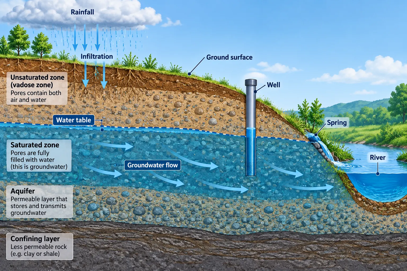
Rain falls or snow melts. Part of that water runs off into streams, and part evaporates. The rest soaks into the soil, a process called infiltration. Near the surface, the water passes through the unsaturated zone, where the gaps between soil grains hold both air and water. Plant roots take up some of this moisture.
Water that escapes the roots keeps sinking under gravity. Hydrologists call this downward movement percolation. Eventually the water reaches a depth where every gap is already full. That boundary is the water table, and everything below it is the saturated zone. Water in the saturated zone is groundwater.
Where the saturated material is porous and connected enough to yield useful amounts of water, the layer is an aquifer. Groundwater in an aquifer does not sit still. Groundwater flows slowly from higher to lower water levels, usually toward a valley, a river or the coast.
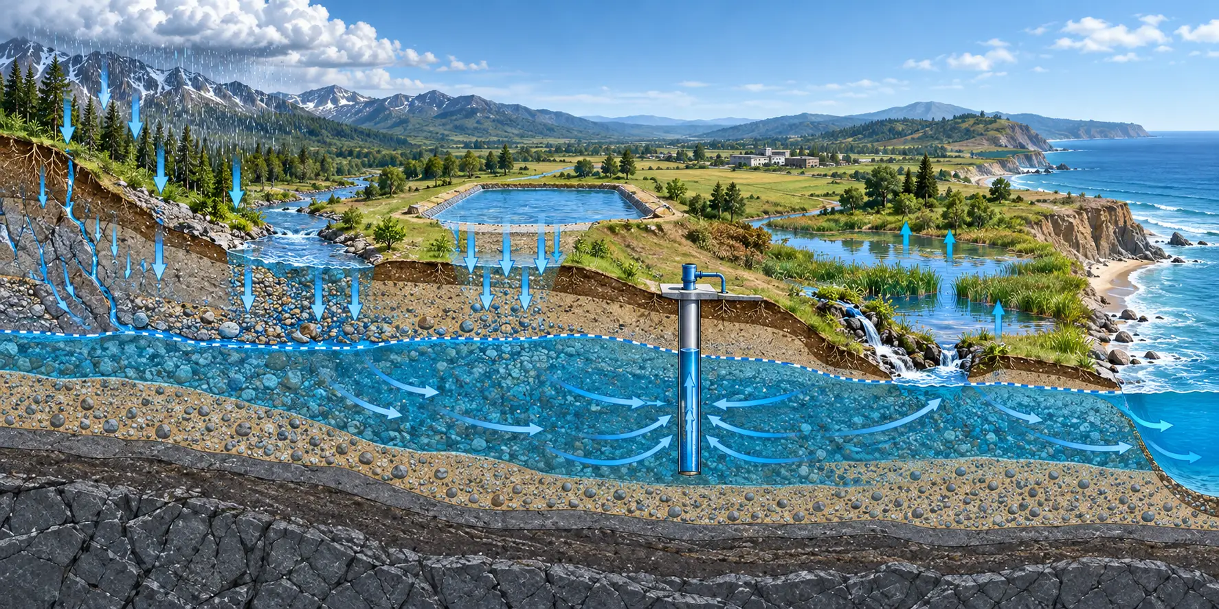
The journey ends in one of two ways. Groundwater leaves naturally through springs, riverbeds, wetlands or seepage into the sea. Or people pump groundwater out through wells. Across the long run, what leaves an aquifer must be balanced by what enters, or water levels fall.
The unsaturated zone, saturated zone and water table
The two zones below your feet
Dig a hole and you pass through two zones.
- Unsaturated zone (vadose zone). The gaps hold both air and water. Plant roots draw moisture from this layer. Water here is soil moisture, not groundwater.
- Saturated zone. Every gap is full of water. Only water in this zone counts as groundwater.
The water table
The water table is the top of the saturated zone. In a wet valley, the water table may sit less than a foot below the surface. In a desert basin, the water table may lie hundreds of feet down.
The water table moves. Spring rain and snowmelt raise the water table. Summer heat, plant growth and heavy pumping lower the water table. A well only yields water while the well bottom stays below the water table.
A shallow water table also matters for buildings. Where the water table rises close to basements, tunnels or excavations, groundwater pressure can push water through walls and floors. Engineers call this seepage into underground structures, and the water table position is the first thing they check.
Groundwater versus surface water
| Groundwater | Surface water | |
|---|---|---|
| Where found | In soil and rock pores and fractures | Rivers, lakes, reservoirs |
| Flow speed | Millimetres to metres per day | Metres per second |
| Time in storage | Days to more than 1 million years | Days to years |
| Response to drought | Slow, buffers dry years | Fast, drops within weeks |
| Natural filtering | High, soil and rock strain particles | Low |
| Cleanup after pollution | Slow and costly, often decades | Faster |
Aquifers: where groundwater is stored
An aquifer is a body of rock or loose sediment that holds groundwater and releases enough groundwater to supply a well or spring. Two properties decide whether a layer works as an aquifer.
- Porosity is the share of open space in the material. More space means more storage.
- Permeability is how well those spaces connect. Better connections mean faster flow.
Clay has high porosity but low permeability. Clay holds groundwater yet barely lets groundwater move. Gravel has both, so gravel makes a strong aquifer.
Common aquifer materials
| Material | How groundwater is stored | Typical yield |
|---|---|---|
| Sand and gravel | Between loose grains | High, among the most productive |
| Sandstone | Between cemented grains | Moderate to high |
| Limestone and dolomite (karst) | In dissolved channels, caves and fractures | Highly variable, can be very high |
| Fractured granite and basalt | In cracks and joints | Low to moderate |
| Weathered hard rock | In broken upper layers | Low, common in peninsular India and Africa |
Valley fill and river deposits in sinking basins form some of the most productive aquifers on Earth, such as the Indo-Gangetic Plain and California's Central Valley. Hard crystalline rock, which underlies much of peninsular India and large parts of Africa, yields far less water per well. Karst limestone, as in Florida, southern China and the Mediterranean, can yield huge volumes through dissolved channels but is also easily polluted.
Unconfined, confined and perched aquifers
- Unconfined aquifer. No sealing layer sits above. The water table forms the top. Rain recharges the aquifer directly from above. Shallow wells tap unconfined aquifers, and pollution from the surface reaches unconfined aquifers faster.
- Confined (artesian) aquifer. A low-permeability layer of clay or shale seals the top. Groundwater sits under pressure. Drill a well and water rises above the aquifer top. If pressure is high enough, water flows out without a pump. That is a flowing artesian well.
- Perched aquifer. A small lens of groundwater sits on a local clay layer above the main water table. Perched aquifers dry out fast.
Australia's Great Artesian Basin shows how large a confined system can be. The basin underlies about 1.7 million km², roughly 22% of Australia. Water enters along the uplifted eastern margin and flows under pressure beneath the dry interior, where springs and flowing bores bring water to the surface.
Aquitards and aquicludes
An aquitard slows groundwater flow but does not stop flow. An aquiclude blocks flow almost fully. These layers split one groundwater system into stacked aquifers, each with different water quality and pressure. In West Bengal, for example, drillers seal off shallow arsenic-rich aquifers with cement and tap deeper, older aquifers that carry little arsenic.
Groundwater recharge
Recharge is the water that reaches the water table and adds to an aquifer. Almost all recharge starts as rain or snowmelt.
Natural recharge
Water infiltrates the soil, percolates through the unsaturated zone, and joins the saturated zone. Rivers, lakes, wetlands, irrigation canals and flooded fields also leak water down into aquifers. In dry regions, much of the recharge happens along stream channels that flow only after storms.
How much water gets through depends on several factors.
- Soil and rock. Sand and gravel pass water quickly. Clay and unfractured rock pass very little.
- Rainfall pattern. Long, steady rain soaks in. Short, intense bursts tend to run off.
- Vegetation. Plants intercept and transpire part of each rainfall.
- Land cover. Roofs, roads and paved yards seal the ground and send water to drains instead of aquifers.
- Depth to the water table. Where the water table is deep, water can take years or decades to arrive.
Recharge areas
Recharge areas are the parts of a landscape where water enters an aquifer. For an unconfined aquifer, the recharge area may be most of the land above the aquifer. For a confined aquifer, recharge often happens only where the aquifer rises to the surface, sometimes hundreds of kilometres from the wells that use the water. Protecting those zones from sealing and pollution protects the whole aquifer.
Hydrogeologists estimate recharge with several methods: chloride mass balance, water-table fluctuation in wells, environmental tracers and isotopes, soil physics measurements, water-balance models, and analysis of river baseflow.
Managed recharge
People can also add water to aquifers on purpose. Managed aquifer recharge (MAR) routes surplus water into the ground so the water can be stored and recovered later. Common recharge structures include:
- Infiltration basins and ponds that let stormwater or river water soak in.
- Check dams and percolation tanks on seasonal streams, widely used in India.
- Recharge wells and shafts that deliver water below low-permeability layers.
- Riverbank filtration, where wells near a river draw water through the riverbed sediments.
- Rooftop rainwater harvesting, which sends roof runoff into recharge pits.
Managed recharge works best where the aquifer has storage space, the source water is clean, and the geology lets water move down freely. Readers who want the engineering detail can learn more about how aquifer recharge is planned and implemented.
How groundwater moves
Groundwater flows from places where the water level (hydraulic head) is high toward places where the head is low. In most landscapes, that means from hills toward valleys, rivers and the coast. Henry Darcy described the rule in 1856: flow rate rises with the permeability of the material and with the slope of the water table.
Q = K \cdot A \cdot \frac{dh}{dl}
Here Q is the flow rate, K is hydraulic conductivity (how easily the material transmits water), A is the cross-section area of flow, and dh/dl is the hydraulic gradient, the change in head over distance.
In sand and gravel aquifers, groundwater usually moves a few millimetres to a few metres per day. River water covers that distance in seconds. Karst limestone is the main exception. In dissolved limestone channels, dye tracer tests often record travel speeds of hundreds of metres to kilometres per day.
How old is groundwater?
Age depends on depth and distance from the recharge area. Shallow groundwater near a recharge zone can be days to a few years old. Deep groundwater in large basins is often thousands of years old. Some US groundwater melted from glaciers that covered North America between about 2.5 million and 10,000 years ago.
In Australia's Great Artesian Basin, groundwater moves about 1 to 5 metres per year. Water near the eastern recharge areas is a few thousand years old. Water discharging in the southwest is up to nearly 2 million years old, based on carbon-14 and chlorine-36 dating.
Scientists date groundwater with isotopes such as tritium (for water up to about 60 years old), carbon-14 (up to tens of thousands of years), and chlorine-36 or krypton-81 (hundreds of thousands of years and more).
Groundwater that receives little or no modern recharge is often called fossil groundwater. Pumping fossil groundwater is closer to mining than to farming. Once removed, the water does not return on any human timescale.
Groundwater discharge
Groundwater leaves aquifers in several ways.
- Springs and seeps, where the water table meets the land surface.
- Rivers and streams. Groundwater flowing into a stream bed is called baseflow. Baseflow keeps many rivers running between rains. USGS studies estimate that groundwater supplies about half of streamflow in the Upper Colorado River Basin, and a median of 54% of streamflow across 276 sites in the Chesapeake Bay watershed.
- Lakes and wetlands. Many lakes and marshes are places where the water table reaches the surface.
- The sea, through submarine groundwater discharge along coastlines.
- Plants, which draw shallow groundwater through deep roots.
- Wells, the human outlet.
How much groundwater is there?
Earth holds about 1,386 million km³ of water. The USGS estimates groundwater, fresh and saline, at about 23.4 million km³. That is less than 2% of all water, but more than 200 times the water in all fresh lakes, rivers and swamps combined.
Where Earth's water sits
| Volume (km³) | |
|---|---|
| Oceans (saline) | 1,338,000,000 |
| Ice caps and glaciers (fresh) | 24,064,000 |
| Groundwater (fresh and saline) | 23,400,000 |
| Fresh lakes, rivers and swamps | 104,590 |
Source: USGS
Set aside the oceans and the ice sheets, and groundwater dominates. Groundwater makes up about 30% of all fresh water and about 99% of the fresh water that is liquid.
Modern versus old groundwater
A 2016 study in Nature Geoscience by Gleeson and colleagues estimated about 22.6 million km³ of groundwater in the upper 2 km of the continents. Pooled evenly over the land, that would stand about 180 m deep.
Less than 6% of that groundwater is modern, meaning recharged within the last 50 years. The best estimate of modern groundwater is about 1.3 million km³, with a range of 0.1 to 5 million km³. Spread over the continents, modern groundwater would form a layer about 3 m deep.
The distinction matters. Modern groundwater renews on a human timescale and supports long-term use, but modern groundwater is also the most exposed to pollution and land-use change. Older groundwater is often better protected, yet refills so slowly that heavy pumping draws down storage.
Large volume does not mean unlimited supply. Much groundwater is too deep, too salty, or too slow to flow to be pumped economically. The usable share is the fresh, shallow, actively recharged part.
How people use groundwater
According to the UN World Water Development Report 2022, groundwater supplies about half of the water withdrawn for household use worldwide, including drinking water for most rural people without piped supply. Groundwater also supplies about 25% of irrigation withdrawals, watering about 38% of the world's irrigated land. Widely cited UN and peer-reviewed estimates put the number of people who rely only on groundwater for daily needs at about 2.5 billion.
Where pumped groundwater goes
The UN report breaks global groundwater abstraction down as follows.
| Use | Share of global groundwater abstraction |
|---|---|
| Agriculture (mainly irrigation) | 69% |
| Domestic (drinking, cooking, washing) | 22% |
| Industry | 9% |
- Irrigation. Groundwater lets farmers water crops through dry seasons and droughts, often with a pump on their own land.
- Drinking water. Towns and cities pump groundwater from wellfields. Rural homes draw groundwater from private wells and hand pumps.
- Industry. Mines, power plants, food processing, chemicals, pharmaceuticals and electronics use groundwater for process water and cooling.
- Heating and cooling. Groundwater stays near a steady temperature year-round, close to the local average air temperature. Ground-source heat pumps use that stable temperature to heat buildings in winter and cool them in summer.
Examples from different regions
The Asia-Pacific region withdraws more groundwater than any other. The UN report lists seven countries in the region, Bangladesh, China, India, Indonesia, Iran, Pakistan and Turkey, among the ten largest users. Together those seven account for about 60% of global groundwater withdrawal.
India pumps more groundwater than any other country. The 2025 national assessment by the Central Ground Water Board (CGWB) reports these figures.
India groundwater, 2025 assessment
| Figure | |
|---|---|
| Annual recharge | 448.52 billion m³ |
| Annual extractable resource | 407.75 billion m³ |
| Annual extraction, all uses | 247.22 billion m³ |
| Stage of extraction, national | 60.63% |
| Share of extraction for irrigation | 87% |
| Assessment units rated over-exploited | 730 of 6,762 (10.8%) |
The national average hides sharp regional gaps. Nine states and union territories, including Punjab, Haryana, Rajasthan and Delhi, extract above the national average, and several extract more than their annual recharge.
The United States withdrew about 82.3 billion gallons of fresh groundwater per day in 2015, according to USGS estimates. The largest single use is irrigation. Groundwater supplies about 37% of the water that US public utilities deliver, and more than 90% of the drinking water for rural people on their own wells. The High Plains (Ogallala) Aquifer, which underlies about 175,000 square miles in eight states, supports one of the world's largest irrigated farming regions.
The Middle East and North Africa rely heavily on groundwater because surface water is scarce. The UN report finds groundwater is the most used water source in at least 11 of the 22 Arab states. Much of that water is fossil groundwater with little modern recharge. Libya's Great Man-Made River, for example, pipes groundwater from beneath the Sahara to coastal cities.
Sub-Saharan Africa shows the opposite pattern. Only about 3% of farmland is equipped for irrigation, and only about 5% of that area uses groundwater. The UN report attributes this low use to missing infrastructure and investment, not to a lack of renewable groundwater.
Australia depends on groundwater across its dry interior. The Great Artesian Basin is the main reliable water source for towns, stations and mines across much of inland Queensland, New South Wales and South Australia.
Groundwater and ecosystems
Groundwater keeps rivers, wetlands and springs alive through dry seasons. Scientists call these systems groundwater dependent ecosystems (GDEs).
- Rivers. Groundwater seeps into stream beds and sustains baseflow between rain events. When pumping lowers the water table below the stream bed, the flow reverses. The river starts losing water to the aquifer and may dry up.
- Wetlands and lakes. Many wetlands are simply places where the water table meets the surface.
- Springs and oases. In deserts, groundwater discharge creates oases that support plants, animals and people.
- Cave and aquifer life. Karst and gravel aquifers host specialised animals found nowhere else.
- Vegetation. Water table depth shapes which plants grow where. Drought-tolerant plants hold the dry hilltops. Water-loving plants line the valleys.
Groundwater also buffers water temperature. Groundwater stays close to the average annual air temperature. In summer, groundwater inflow cools streams. In winter, groundwater inflow keeps streams warmer. Trout and salmon rely on these cool pockets during heat waves.
The World Bank's 2023 report The Hidden Wealth of Nations notes that groundwater sustains wetlands, lakes, swamps and forests that store carbon. Lose the groundwater and you lose those carbon stores too.
Damage to GDEs is easy to miss. Pumping lowers the water table slowly, and ecosystems decline over years or decades. By the time a spring stops flowing, the aquifer may need decades to recover.
Groundwater depletion
Groundwater depletion is a long-term fall in the amount of water stored in an aquifer. Depletion happens when pumping, over many years, takes out more water than recharge puts back. Storage in most aquifers is large compared with yearly inflow, so an aquifer can be overdrawn for decades before wells fail. That slow response often hides the problem until fixing it is expensive.
Depletion is not universal. Many aquifers are stable, and some are recovering. The pattern is uneven, concentrated where dry climates meet heavy irrigation.
Pumping and drawdown
When a well pumps, the water level around the well drops. The lowered water table takes the shape of a funnel, called a cone of depression. The drop at any point is the drawdown.
- A small, well-spaced well creates a shallow cone that recovers when pumping stops.
- Many wells close together create overlapping cones. Neighbouring wells lose water level, and shallow wells can go dry.
- A cone that reaches a stream can reverse the flow between river and aquifer. The stream then loses water into the ground instead of gaining water from the ground.
What the data shows
- Rapid declines are common in dry farming regions. A 2024 study in Nature analysed about 170,000 monitoring wells across 1,693 aquifer systems in countries covering about 75% of global groundwater withdrawal. Rapid declines of more than 0.5 m per year are widespread in the 21st century, especially in dry regions with extensive cropland. Declines sped up over the past four decades in 30% of the regional aquifers studied.
- Satellites show the same pattern. NASA's GRACE satellites measure small changes in Earth's gravity caused by shifting water mass. A 2015 GRACE study found 21 of the world's 37 largest aquifer systems losing water between 2003 and 2013. The most stressed was the Arabian Aquifer System.
- Global losses are large. The IPCC Sixth Assessment Report estimates global groundwater depletion at roughly 100 to 300 km³ per year, driven mainly by irrigated agriculture in drylands.
- Many wells sit close to the water table. A 2021 study in Science reviewed about 39 million wells in 40 countries. Between 6% and 20% were no more than 5 m deeper than the local water table, so a decline of a few metres could leave them dry.
- The effect is measurable at planetary scale. A 2023 study in Geophysical Research Letters estimated that about 2,150 gigatonnes of groundwater were pumped out between 1993 and 2010, with most ending up in the ocean. That shift in mass moved Earth's rotational pole by about 80 cm and added roughly 6 mm to global sea level.
Examples of heavily stressed aquifers
| Region | What the evidence shows |
|---|---|
| Northwest India (Punjab, Haryana, Rajasthan, Delhi) | Extraction above the national average, in places above annual recharge (CGWB) |
| California Central Valley, USA | A recognised depletion hotspot linked to irrigation (IPCC) |
| High Plains (Ogallala) Aquifer, USA | Declines of more than 150 ft since about 1950 in parts of Texas, Oklahoma and Kansas, while levels in much of Nebraska changed little (USGS) |
| North China Plain | A recognised depletion hotspot linked to irrigation (IPCC) |
| Arabian Aquifer System | The most stressed of the 37 largest aquifers in the GRACE analysis |
| Iran | Several aquifer systems among the fastest declines in the 2024 Nature dataset |
| Southeast Spain | The Ascoy-Sopalmo aquifer showed the fastest median decline in the Nature dataset, close to 3 m per year |
Recovery is possible
The same Nature study found aquifers recovering in places such as Bangkok, Arizona and New Mexico. Each case followed action: pumping limits, pumping charges, or bringing in surface water to replace groundwater and refill the aquifer.
Land subsidence
In a natural aquifer, water pressure in the pores holds up part of the weight of the sediments above. Pump the water out and that pressure drops. Clay and silt layers squeeze together, and the land surface sinks. Most compaction in clay is permanent, and the aquifer loses storage space for good.
- Parts of California's San Joaquin Valley sank close to 9 m (about 28 ft) during the 20th century, according to USGS records.
- Mexico City, built on an old lake bed, sinks about 35 cm per year in the fastest areas, according to a 2021 study combining a century of survey, satellite and GPS data. The study found almost no rebound, so the lost elevation and storage are effectively permanent.
- Jakarta, Bangkok, Venice and New Orleans have all subsided partly because of groundwater pumping.
Subsidence cracks roads, pipelines, canals, well casings and foundations. In coastal and delta cities, sinking land adds to sea level rise and increases flood risk.
Saltwater intrusion
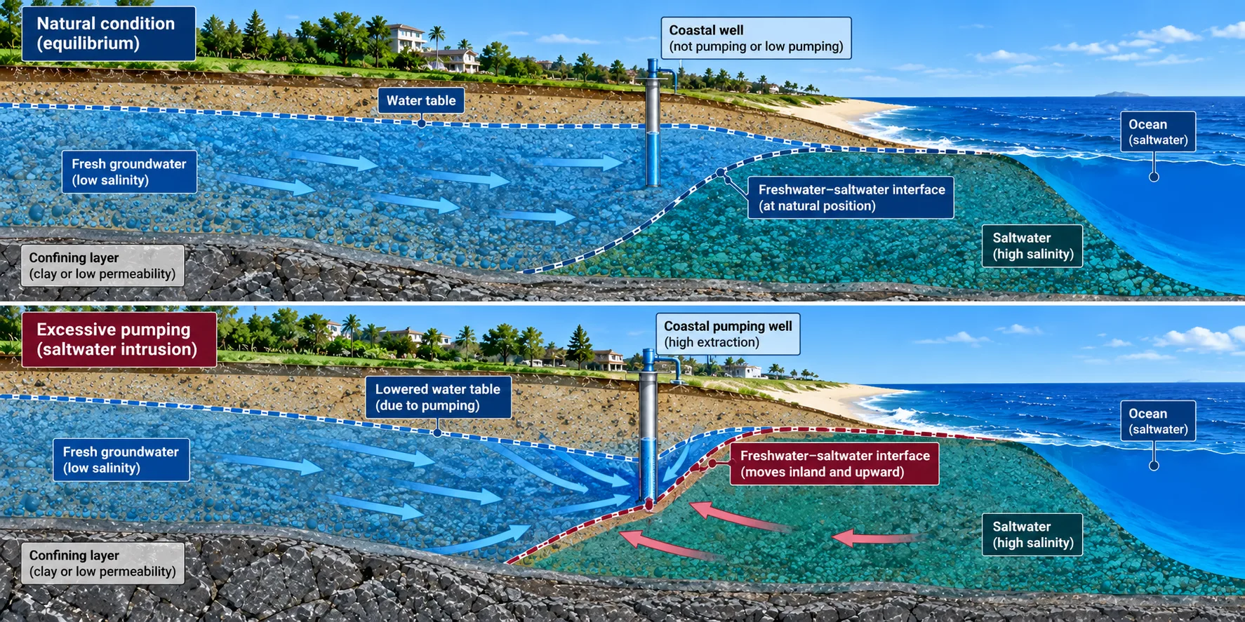
Along a coast, fresh groundwater floats on top of denser seawater inside the aquifer. The fresh water forms a lens that thins toward the shore. Between the two sits a mixing zone called the freshwater-saltwater interface. Pump too hard near the coast and the interface moves inland and upward, toward the wells.
The Ghyben-Herzberg relation gives a rule of thumb for simple sandy aquifers. For every 1 m of fresh water table above sea level, fresh groundwater extends about 40 m below sea level.
z = 40 \cdot h
Here z is the depth of fresh water below sea level and h is the height of the water table above sea level. The rule works in both directions. Lower the water table by 1 m and the interface can rise by about 40 m.
A small amount of seawater spoils a lot of fresh water. Seawater carries about 19,000 mg/L of chloride, while drinking water guidelines for taste sit around 250 mg/L. Mixing in only 1% to 2% seawater is enough to push chloride past that level.
Examples from different coasts:
- United States. A 2020 study in Nature Communications of about 250,000 coastal groundwater observations found that most groundwater levels sit below sea level along more than 15% of the contiguous US coastline, a setting that favours intrusion. The Biscayne Aquifer under Miami and coastal aquifers in New Jersey are long-studied examples.
- Bangladesh. Coastal aquifers and the Sundarbans mangroves face rising salinity from sea level rise, storm surges and pumping.
- Small islands. The fresh lens is thin, often only metres thick, and has no inland backup.
- Arid coasts. In parts of the Gulf region and North Africa, heavy pumping has drawn saline water into coastal aquifers.
Pumping is usually the main cause of seawater intrusion. Sea level rise and storm flooding add to the problem. Common responses include moving wells inland, reducing coastal pumping, injecting fresh water to form a hydraulic barrier, and tracking salinity in sentinel wells between the coast and the main wellfield.
Groundwater contamination and quality
Most groundwater is fit for common uses. Soil and rock strain out particles and many microbes, and slow flow gives time for some chemicals to break down. But that natural filter has limits. Dissolved chemicals can pass straight through. Coarse sand and fractured rock let pollutants travel fast. Buried tanks, septic systems and waste pits release pollution right next to the water table, with little soil in between.
Groundwater also carries dissolved minerals from the rocks it passes through. The most common are calcium, magnesium, sodium, potassium, bicarbonate, chloride and sulfate. These give groundwater its taste and hardness and are usually harmless.
Natural (geogenic) contaminants
Some rocks release harmful elements into groundwater with no human help.
| Contaminant | Examples of affected regions | Main health concern |
|---|---|---|
| Arsenic | Bengal Basin (West Bengal and Bangladesh), Mekong delta, parts of Argentina and the US Southwest | Skin lesions, cancers, cardiovascular disease |
| Fluoride | Parts of India, the East African Rift and northern China | Dental and skeletal fluorosis |
| Salinity | Arid basins and coastal aquifers | Unfit for drinking and many crops |
| Iron and manganese | Many river-deposit aquifers | Taste and staining, neurological risk at high manganese levels |
| Uranium and radon | Granite and some sedimentary aquifers | Kidney effects (uranium), lung cancer risk (radon) |
In the Bengal Basin, arsenic is concentrated in younger, shallower aquifers. Deeper, older aquifers are often low in arsenic, which is why sealed deep wells are used as safer sources in parts of West Bengal and Bangladesh.
Human sources
Point sources have one clear origin.
- Leaking underground fuel and chemical storage tanks.
- Landfills without liners, or with damaged liners.
- Septic tanks and pit latrines placed too close to wells.
- Industrial waste lagoons, mine tailings and oilfield brine pits.
- Spills of dense chlorinated solvents, such as dry-cleaning fluid. These sink below the water table and are among the hardest pollutants to remove.
Non-point sources spread across wide areas.
- Nitrate from fertiliser and manure, a common groundwater pollutant in farming regions.
- Pesticides and herbicides.
- Road de-icing salt.
- Leaking sewers under cities.
PFAS
PFAS are synthetic chemicals used in non-stick coatings, firefighting foam and water-repellent products. They resist natural breakdown, which is why they are often called forever chemicals. A 2024 USGS study estimated that 71 to 95 million people in the lower 48 US states, more than 20% of the population, may rely on groundwater with detectable PFAS for drinking water. PFAS detections in groundwater are also reported across Europe, Australia and Asia.
How contamination spreads
A pollutant that reaches the water table forms a plume. The plume moves with groundwater flow and spreads sideways as the water mixes. Because groundwater moves slowly, a plume may take years to reach a well, and years more to be noticed.
Why cleanup is difficult
Once an aquifer is polluted, restoring the water is slow and costly. Contaminants cling to sediments, sink into low-permeability layers, and leach back out for years. Common approaches include pumping and treating the water at the surface, air stripping of volatile chemicals, activated carbon filtration, air sparging, and bioremediation that uses microbes to break down pollutants. Many projects run for decades. Prevention costs far less than cleaning up contaminated groundwater.
A well-known case is Ville Mercier, Quebec, where industrial waste dumped into an old gravel pit made the local groundwater unusable. The community had to bring in water by pipeline from about 10 km away.
Advice for private well owners
Public water systems test and treat water under national rules. Private wells usually do not. If your household uses a private well, test at least once a year for bacteria and nitrate, and for any chemical known in your area, such as arsenic, fluoride or PFAS. Local health departments can point you to certified laboratories and explain the results. Regular checks of groundwater quality are the only reliable way to know what is in the water.
Climate change and groundwater
Climate change hits groundwater mostly through demand. Hotter weather raises crop water needs. Erratic rain dries up surface supplies. Farmers and cities then pump more groundwater to fill the gap.
How recharge is changing
- Heavier, fewer storms. In many tropical regions, intense rain drives more water into aquifers. Some aquifers in Africa and South Asia may see more recharge, not less.
- Longer droughts. Dry, compacted soil lets less water soak in, so recharge falls.
- Less snow. In mountain and high-latitude regions, a shorter snow season cuts spring recharge.
- Shrinking glaciers. The long-term effect of glacier loss on groundwater is still poorly understood.
Groundwater is getting warmer
Shallow groundwater warms as the land surface warms. A 2024 study in Nature Geoscience projects that groundwater at the depth of the water table will warm by about 2.1 °C on average by 2100 under a medium emissions pathway. About 30 million people already live where groundwater is warmer than the strictest national drinking water temperature guideline. Under the same pathway, that number is projected to reach 77 to 188 million by 2100. Warmer groundwater holds less dissolved oxygen and can favour the growth of harmful microbes.
Groundwater quality under climate stress
- Big storms flush fertiliser, sewage and latrine waste into shallow aquifers.
- Droughts shrink river flow, so pollutants reach groundwater less diluted.
- Sea level rise pushes seawater further into coastal aquifers.
Groundwater as a climate buffer
Groundwater is one of the best tools for coping with a hotter, less predictable climate. Aquifers store water underground, safe from evaporation, and release water through drought years. The World Bank's 2023 report finds that groundwater can buffer about a third of the economic growth lost to droughts, and up to half of the farm productivity lost to rainfall swings.
Groundwater also supports climate mitigation.
- Ground-source heat pumps and aquifer thermal energy storage cut heating and cooling emissions. The Netherlands and Sweden already use aquifers as seasonal heat stores in district networks.
- Deep saline aquifers can store captured carbon dioxide.
The most vulnerable aquifer systems include low-lying coastal and delta aquifers, aquifers in alpine and polar regions, shallow aquifers under seasonal rivers in drylands, and intensively pumped aquifers that supply dryland farms and cities.
How scientists study and monitor groundwater
Nobody can see an aquifer directly, so knowledge of groundwater is built from indirect evidence. Hydrogeologists, the scientists who specialise in groundwater, combine maps, surface surveys, boreholes, pumping tests and water samples into a picture of what lies below. The steps below describe how that picture is usually assembled. Readers interested in applied project work can see how groundwater investigations are used in real-world projects.
1. Desk study and aquifer mapping
The work starts with geological maps, satellite imagery, existing well logs and regional water level records. From these, hydrogeologists map likely aquifer zones, recharge areas, faults and fracture belts. In India, CGWB's national aquifer mapping programme (NAQUIM) provides a base layer for this step.
2. Geophysical surveys
Geophysics reads the ground without digging.
- Electrical resistivity (vertical electrical sounding and 2D imaging). Saturated sand and fractured rock conduct electricity differently from dry rock or clay. This is the most common method for borewell siting.
- Electromagnetic surveys map clay layers and saline zones.
- Seismic refraction shows depth to bedrock and weathered zones.
- Ground-penetrating radar images shallow layers and the water table.
3. Test drilling and borehole logging
Test wells confirm what the surveys suggest. Drillers log each layer, collect soil and rock samples, and record the depth where water enters. Borehole geophysical logs (gamma, resistivity, caliper, temperature) mark the exact water-bearing zones.
4. Pumping tests
A pumping test measures how an aquifer responds to a known pumping rate. Water levels are logged in the pumped well and nearby observation wells, during pumping and during recovery. The results give:
- Transmissivity: how easily water flows through the full aquifer thickness.
- Storativity: how much water the aquifer releases per metre of head drop.
- Safe yield: how much a well can pump long-term without drawing the aquifer down too far.
- Radius of influence: how far the drawdown spreads, and which neighbouring wells or streams it affects.
5. Water quality testing
Labs test for major ions (calcium, magnesium, sodium, potassium, chloride, bicarbonate, sulfate), nitrate, fluoride, arsenic, iron, manganese, bacteria, and site-specific pollutants such as solvents, hydrocarbons or PFAS. Isotopes such as tritium, carbon-14 and nitrogen-15 reveal groundwater age and trace pollution sources.
6. Groundwater modelling
Numerical models (the USGS code MODFLOW is a common standard) simulate how groundwater levels and flow will respond to new wells, mine dewatering, construction, drought or recharge projects. Models help size wellfields, predict drawdown, design dewatering for excavations and mines, and plan remediation.
7. Long-term monitoring
- Automatic pressure sensors in observation wells record water levels as often as every few minutes.
- Regular sampling tracks quality trends.
- Satellites such as GRACE and GRACE-FO track regional storage changes from orbit.
- National networks publish public data: the USGS National Ground-Water Monitoring Network in the US and CGWB's India-WRIS and IN-GRES in India.
Long-term monitoring is essential because groundwater levels and quality can change gradually over years or decades. Wide gaps remain in Africa, South America and Southeast Asia, where monitoring wells are scarce.
Groundwater management and protection
Sustainable groundwater management considers how much water enters, leaves and is stored in an aquifer, while also accounting for the effects of pumping on groundwater levels, connected rivers, wetlands, ecosystems and other users.
Supply side: put more water back
- Managed aquifer recharge (MAR). Route rainwater, floodwater, treated wastewater or surplus river water into aquifers through infiltration basins, check dams, recharge wells and riverbank filtration.
- Rainwater harvesting. Capture roof and paved-area runoff and send the water into recharge pits or shafts. Many Indian cities, including Chennai and Bengaluru, require rainwater harvesting on new buildings.
- Sponge cities. Design parks, permeable pavements and wetlands so urban land soaks up rain rather than shedding rain into drains.
- Protect recharge zones. Keep high-recharge land, such as sandy uplands and river floodplains, free from paving and polluting uses.
Demand side: pump less
- Meter wells and set pumping caps.
- Switch from flood irrigation to drip and sprinkler systems.
- Shift water-hungry crops out of stressed basins.
- End free or flat-rate electricity for farm pumps. Free power removes any cost signal for pumping.
- Reuse treated wastewater for industry and landscaping.
Quality: stop pollution at the source
Prevention is far cheaper than cleanup.
- Draw wellhead protection zones around supply wells and limit risky land uses inside them.
- Line landfills and waste lagoons. Replace old steel fuel tanks with double-walled tanks and leak detection.
- Site septic systems and latrines a safe distance from wells.
- Cut fertiliser and pesticide overuse with soil testing and precision application.
- Seal abandoned wells. An open well is a direct path for surface pollution into the aquifer.
Governance
Groundwater is hard to govern because groundwater often counts as private property tied to land, while aquifers cross property lines, district lines and national borders. Strong frameworks share a few features.
- Clear rights and permits for large abstractions.
- Sustainable yield limits set from aquifer data.
- Joint (conjunctive) management of groundwater and surface water.
- Public monitoring data.
- Local user groups with a real say, since farmers and towns hold the pumps.
India's Atal Bhujal Yojana, California's Sustainable Groundwater Management Act (SGMA) of 2014, and the EU Groundwater Directive are three current examples of national-scale groundwater law.
What you can do
- Fix leaks and cut outdoor watering.
- Install a rainwater recharge pit if you own land.
- Never pour oil, paint, solvents or medicines down drains or onto the ground.
- Maintain your septic tank.
- Test your well water once a year if you rely on a private well.
Groundwater FAQ
What is groundwater in simple words?
Groundwater is rain and snowmelt that has soaked into the ground and filled the gaps in soil, sand and rock below the water table.
Where does groundwater come from?
Almost all groundwater starts as precipitation. Rain and snowmelt soak down through the soil until they reach the saturated zone. Rivers, lakes and irrigation canals also leak water into aquifers.
Is groundwater renewable?
Partly. Shallow groundwater in humid regions renews over months to decades. Deep, old groundwater may take thousands of years or more to refill. Groundwater behaves as a renewable resource only where long-term pumping stays below recharge.
How deep is groundwater?
The water table can sit less than 1 foot below the surface in wetlands, or hundreds of feet down in deserts. Depth also rises and falls with seasons and pumping.
Is groundwater safe to drink?
Often, but not always. Natural arsenic, fluoride, salt, bacteria from septic systems, nitrate from farms, and industrial chemicals can all make groundwater unsafe. Test before you drink.
What is the difference between groundwater and an aquifer?
Groundwater is the water. An aquifer is the rock or sediment layer that holds and yields the groundwater.
What is an artesian well?
An artesian well taps a confined aquifer where groundwater is under pressure. Water rises in the well above the top of the aquifer, and sometimes flows out at the surface without a pump.
Why does a well go dry?
A well goes dry when the water table drops below the pump intake. Drought, heavy nearby pumping, or a well drilled too shallow can cause this. The well may recover when recharge returns.
Which country uses the most groundwater?
India. India's Central Ground Water Board puts national extraction at about 247 billion m³ per year (2025), about 87% of which goes to irrigation. That is commonly estimated at roughly a quarter of global groundwater use.
How fast does groundwater move?
Usually a few millimetres to a few metres per day. In karst limestone, groundwater can move kilometres per day.
Can earthquakes affect groundwater?
Yes. Seismic waves can make well water levels rise and fall. Some wells show a lasting level change after a large quake. The largest recorded rise is about 1 metre.
How can groundwater levels be checked?
Most countries publish water level data from national monitoring wells. In the US, use the USGS National Ground-Water Monitoring Network. In India, use CGWB's India-WRIS portal. In Australia, use the Bureau of Meteorology's Australian Groundwater Explorer. For a single property, a well driller or local water authority can measure the depth to water in an existing well.